Severe Thunderstorm Watch Issued for Northeast: NYC Braces for Damaging Winds and Hail
June 6, 2026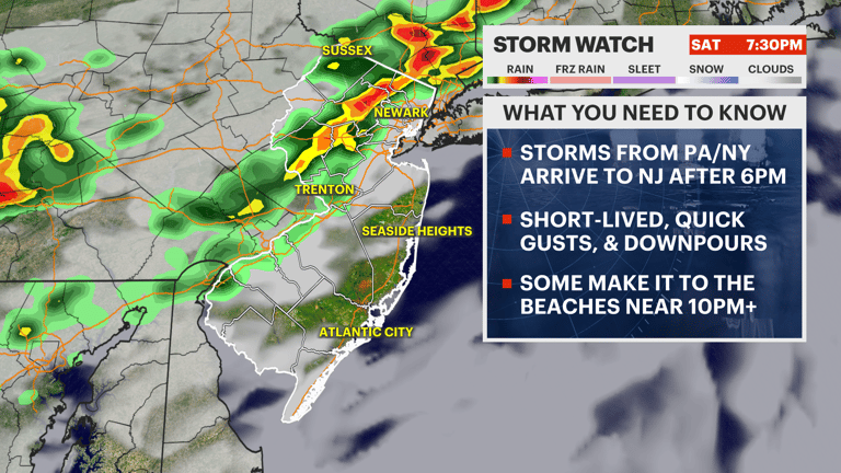
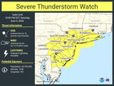
A severe thunderstorm watch is in effect for parts of New Jersey, New York, Pennsylvania, Connecticut and Delaware through 10 p.m. Saturday as storms move in ahead of a cold front.
Around late afternoon, a weather front is expected to enter the area, potentially triggering thunderstorms.
The National Weather Service warns of strong to severe thunderstorms in northern Connecticut from early evening to late night, with the highest risk northwest of I-95 and interior Southern New England.
The watch area includes New York City and surrounding counties from Long Island to Westchester and beyond.
The primary threats during the storms include damaging winds, large hail, frequent lightning, and heavy rainfall capable of localized urban and creek flooding.
Isolated flash flooding is possible in low-lying areas, though overall flood risk remains low due to rapid storm movement and generally under an inch of rain.
Highs today are expected near the upper 80s to 90s, with humid conditions that could fuel storm development tonight.
The most active storm window is late afternoon to early evening, with peak conditions likely around early evening and showers or storms continuing into late night.
A First Alert Weather Day has been declared for late Saturday afternoon through the evening due to potential severe weather in the NYC area.
CBS News New York will provide live storm updates starting in the early evening via its live stream.
Looking ahead, the extended forecast shows mainly sunny days with some chances of showers, and warm highs in the 80s to upper 80s, followed by mostly dry conditions into next week.
Overall takeaway: prepare for a weather-aware evening with potential storms, then quieter conditions overnight and a more pleasant weekend.
Summary based on 7 sources